
Remote sensing 101
TRUE aims to collect emissions data from as many vehicles as possible in each city.
Remote sensing technology allows researchers to measure the exhaust of thousands of vehicles each day, providing robust data to close the gap between laboratory and on-road emissions.
Whatever the cause of the performance gap—equipment failure, normal deterioration with use, or deliberate efforts to cheat regulations–monitoring of emissions is crucial to achieving real-world improvements.
How it works
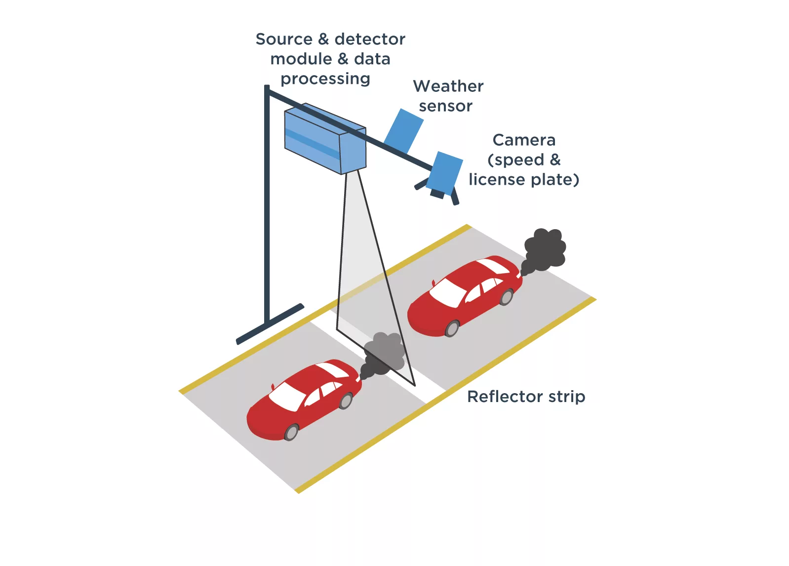
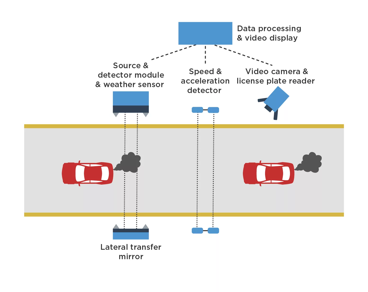
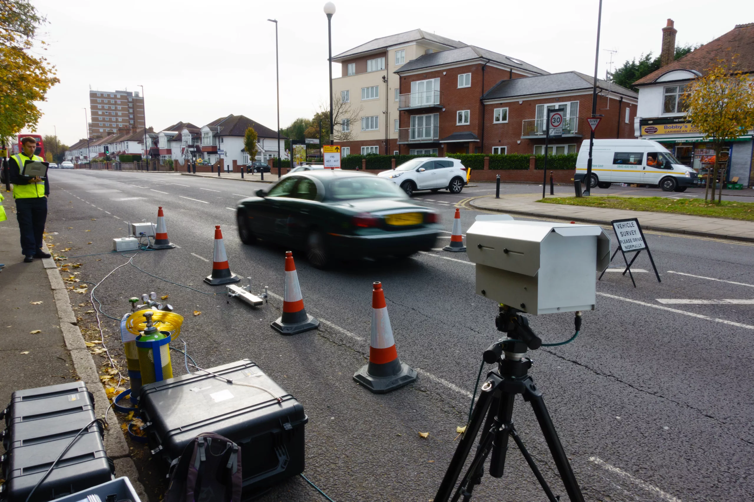
Remote sensing systems use absorption spectroscopy to non-intrusively measure pollutant concentrations in the exhaust plumes of in-use vehicles. A light source and detector are placed either beside or above a roadway, with the instrument oriented so that the light beam produced by the source traverses the exhaust plumes of vehicles passing. Pollutants in the vehicle exhaust can be determined by measuring how much light of certain wavelengths is absorbed as the light beam passes through the plume.
Top-down remote sensing
Cross-road remote sensing
Each remote sensing measurement lasts for less than one second and yields an estimate of the concentration of pollutants, including:
- Nitrogen monoxide (NO)
- Nitrogen dioxide (NO2)
- Carbon monoxide (CO)
- Hydrocarbons (HC)
- Carbon dioxide (CO2)
- Sulfur dioxide (SO2)
- Ammonia (NH3)
- Particulate matter (PM) emissions are measured indirectly using plume opacity
Benefits of remote sensing
Remote sensing enables the measurement of real-world emissions from a very large number of vehicles in a short period of time. A well-placed instrument can measure thousands of vehicles each day. While each individual measurement is only a snapshot of the emissions from a single vehicle, the total sample can provide detailed information on emissions from not only the measured fleet but also specific subgroups within it.

Application today
Today, commercial remote sensing and other contactless vehicle exhaust measurements are used by governments and organisations around the world to monitor emissions.
These measurements can assist with:
- Monitoring of fleet emissions and market surveillance
- Screening for high/low emitters, leading to enhanced inspection and maintenance programs
- Determining the effectiveness of existing emission standards and the development of new regulations
- Research advancement for emissions inventories
History of remote sensing
Development and use of remote vehicle emissions sensing has been growing in recent years. Early systems were pioneered by Gary Bishop and Donald Stedman at the University of Denver, funded initially by the Colorado Office of Energy Conservation and later by the California Air Resources Board (CARB) in the late 1980s.
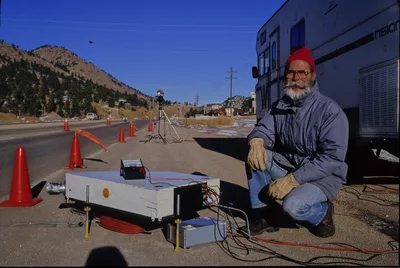
The original system, called the Fuel Efficiency Automotive Test (FEAT), was used to identify gasoline vehicles with high carbon monoxide (CO) emissions for repair, with the goal of both reducing in-use emissions and improving fuel efficiency.
The device was later used on Swedish roads in 1991, and more broadly across Europe for research purposes. Today, remote sensing technology has become a powerful tool for measuring real-world emissions, and measurements have been collected on every continent except Antarctica.
Role of road-side remote sensing in Dieselgate
Before the Dieselgate scandal broke in September 2015, evidence of large discrepancies between real-world and laboratory vehicle emissions began to emerge across Europe thanks to remote sensing tests. Campaigns from the early 2000’s in the United Kingdom, Sweden, and Zurich added hints of suspicion.
Research from ICCT using portable emission measurement systems in the US and Europe provided compelling proof of excess NOx emissions on multiple diesel vehicle models.
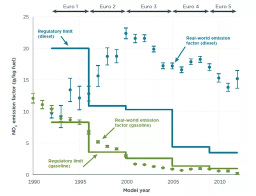
The effects of Dieselgate continue to be far reaching today. Remote sensing participated in providing evidence for the development in Europe of limits for vehicles while driving on the road, and not anymore limited to narrow laboratory conditions.
Since 2018, the European Commission suggests countries may use remote sensing to monitor vehicle emissions to inform potential model recalls. In 2025, the European Commission is also recommending enhancing the periodic technical inspection of vehicles by using remote sensing to detect individual high emitters.
Other techniques used to capture emissions
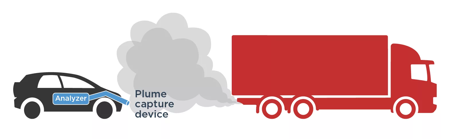
Plume chasing
A vehicle equipped with on-board emission analyzers chases vehicles while sampling the air behind them. A portion of the target vehicle exhaust plume is captured using a sampling line with its inlet on the exterior of the chase vehicle. This exhaust sample is routed to pollutant analyzers to measure exhaust concentrations. That technique is particularly useful to obtain minutes long of emission recording and therefore effective to assess the emissions of individual vehicles.
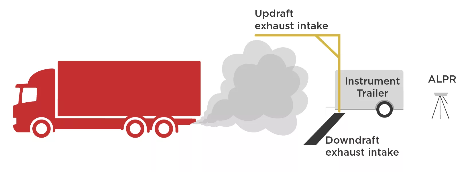
Point sampling
The air in the vicinity of the exhaust’s plume is actively aspirated. The measurement method is similar to the plume chaser, except that target vehicles drive past a fixed sampling location with sampling inlets placed in close proximity to the tailpipes/exhaust stacks of passing vehicles.